If you are viewing this on your phone and do not see 3 columns then scroll left/right or switch to webpage or computer view.

Showing posts with label State: Missouri. Show all posts

Saturday, October 5, 2019

2019 Littrell Family Reunion: October 19, 2019

descendants of John & Kizzie Comer Littrell

How to get to the reunion:

www.littrellfamily.net is an open website, meaning anyone can view it, for this reason we limit the information we post here. We do not share the reunion site address here as it is a private residence all year round.

The reunion site is the same place as the last 7 years. If you haven't been there then try to contact a first cousin or any cousin who has been there for directions.
We have a Facebook group page that you can request membership in and once your membership is approved you will have access to more specific information. If you aren't on Facebook email me at
indianaglenn@gmail.com 

Please don't wait to the last minute to get information as those of us trying to coordinate things will be busier as the date approaches. At some point we will be unreachable by internet as there is no internet on-site.

Presently we advise everyone coming to make lodging arraignments soon. On the day of the reunion** we can have a meeting point in Doniphan for those who don't know the way. {email me if you want to set this up)

GlennDL

**the day before also if necessary.

doniphan
http://www.rockyriverresort.com/rocky-river-inn.html
http://www.rockyriverresort.com/currentriverinn.html
North End Motel- 573-996-2164

If you are camping let us know. There's room for campers and tents… There are hookups, but limited, and facilities for tent dwellers are a port-a-let.

If any of our links are/info is outdated let me know.

Monday, January 29, 2018

The 1937 Flood:

re-posted from January 2015
In January 1937, John and Kizzie lived near Walnut Grove and East Prairie (Missouri). During that winter, there was severe flooding on the Tennessee and Kentucky side of the Mississippi. As the flooding got worse, officials decided that the third dike would be dynamited to save East Prairie. Blowing the dike would also relieve flooding on the other side of the river. At the time, the family lived in a "stilt" house on the River Plain (spillway), so Kizzie and most of the family loaded up and headed for Tennessee.1 2
Even as they left, the water was floorboard high on the truck they were riding in. Bertha and Red remained with Dad and moved everything they could up into the loft.
Most of the families in the flood plain temporarily moved into east Prairie - but Dad, Bertha, and Red loaded up the Model T, and along with Alf Ball and his two wagons and eight mules moved into a two-story house with _____(?) for 3-4 weeks during the flooding. The water was so high that it almost reached the second story. Local whiskey makers stayed in business by moving their stills into their lofts.
Whiskey was obtained by floating up to the lofts.
After the water had receded, the family returned to the house, which had floated over a mile away. What was not moved out of the house or placed in the loft was lost. Unfortunately, the Family Bible was in some boxes (or a trunk) lost to the flood. Evidently, Kizzie tried to record all the family information into a new Bible from memory at a later date. But much of that information has proven unreliable.
1937flood
1 The Weekly Record, January 29, 1937, February 5, 1937: This was one of the countless floods that plague the Mississippi throughout history. There have been worst floods before and since, but this was the first to impact our family. The 1937 flood was particularly hard for the river spillway families as over 500 (1500-2000 people) families had to be evacuated. The fear was that the newly built levee would not hold in light of predictions that the river would crest at 1 foot higher than the devastating 1927 flood that broke the Dorena Levee. Over 20 feet of water flooded the spillway, and 23 WPA workers died in a spillway accident when their barge carrying 150 levee workers sank in the spillway. Families would again be forced out in May as flooding threatened the spillway farmers again. Flooding this time was imminent as the levees had not been repaired, but at least the area was not plagued by the snow, sleet, and freezing temperature that accompanied the January flood.
2 Onene Littrell-Curtis, Bertha Littrell-Thurman, Red Littrell, & JD Littrell gdl/1994
Newspaper clipping from the “Remember East Prairie When:” Facebook page.
also: http://en.wikipedia.org/wiki/Ohio_River_flood_of_1937
68 / 100 / 216 / 220 / 241


Tuesday, October 24, 2017

The Boys of Anniston, MO.

John and Kizzie lived most of the 40s in and around the little town of Anniston, Missouri. By the time they moved from Anniston into East Prairie all their children were grown and had moved out.  Bertha was the last Littrell (Thurman) to move from Anniston, taking her family to Charleston, Missouri. Several of John’s sons would list Anniston on their enlistment papers as their residence when enlisting for World War II and/or Korea.

reposted from 03/12/06

This spring I was in southeast Missouri doing some research for a family history on the family’s of my grandfather, John Daniel Littrell, and his brother James Carroll Littrell. The particular information I was looking for was the military service of their sons.  While visiting the libraries of Mississippi and New Madrid Counties I was amazed at the number of enlistees from the two counties during World War II and the Korean conflict.  During WW II virtually every issue of the area newspapers listed 50, 75, 100 local boys reporting for service.  The numbers were staggering when one considers that this was not a densely populated area. While contributing more than its fair share of young men to the war effort these numbers could not have been achieved without many families sending more than one son off to war.  In John Littrell’s family alone five sons and two son-in-laws served between 1941 and 1952.

The last stop on this particular trip was a visit to the cemetery located in Anniston, Missouri to obtain a photograph of 603TSBordie_crppd Lindsie Prior “Bordie” Thurman’s headstone.  Bordie was an Army Air Corps Veteran of World War II and the husband of Bertha Ann Littrell, John Littrell’s third daughter.

While growing up I had spent several summer vacations with my grandparents John and Kizzie (Comer) Littrell in East Prairie, Missouri and lived for a short time in Marston, but was only vaguely familiar with those areas.  I had heard of Anniston and knew that my grandparents had lived there prior to settling in East Prairie but had never actually been there.  Upon arriving in Anniston it was obvious that the little town had seen more robust times, I probably had unrealistic expectations based on family stories from my youth.  Gone were the theater, school, and cafĂ© that were prominent in those recollections.  

Upon finding the cemetery I began looking for Uncle Bordie’s headstone.  As I searched I became aware of two oddities concerning the little cemetery.   

The first oddity was that the population of the graveyard appeared to be close to or greater than the population of the town (288).  This by itself is not unique; I have visited hundreds of cemeteries in Kentucky, Tennessee, and Missouri over the last ten years, and have seen many towns where the dead outnumbered the living.  What was different about Anniston though was that neither the town nor the cemetery appeared to be as old as the other towns that had this same situation.

The second oddity however was very unique.  As I wandered among the headstone it struck me that a large portion of the headstones had ‘Veteran Plaques’, eventually this realization was overwhelming so I started counting the headstones that were those of veterans.  By the time I found Bordie’s headstone it was apparent that anywhere from a fourth to a third of the occupants of Anniston Cemetery were veterans of WWII and Korea.  I have never seen such a large percentage of veterans in any post civil war cemetery.  If you figure that half of the occupants of the cemetery are females then that means more than half of the male population in the quaint little cemetery served their country.  Even if the population of Anniston during this time was twice as large as it is now the contribution of this little town was a significant portion of the male population when you consider that the cemetery only represents residents and former servicemen who chose to be buried there.  I myself know of at least 5 former residents (brothers) and veterans of this period who were not buried here: Les, Red, Rubin, OJ and JD Littrell.   

whatisavet  As Veterans Day approaches and our thoughts are focused on veterans past and present the people of southeast Missouri should be proud of the contributions of the many families in the area during this century.  While John and Kizzie Littrell had five sons and two son-in-laws serve their country and at least 11 grandchildren do the same, it should be recognized that the service of their descendants and of communities such as Anniston is more representative of what patriotism is than the chest thumping and rabble rousing that all to often passes as patriotism.

Let us pray for our troops and pray against the conflicts that put them in harms way

Glenn Littrell   03/12/06


The above information is from: Military Role Call: The Littrell Family of Mississippi County, Missouri, The Littrell Family Journals Volume IV. (click here)
also: 
Littrell Family Veterans Video

Anniston Cemetery  

reposted from 2013: 216 / 244

Friday, May 19, 2017

2017 Littrell Family Reunion: October 21, 2017

descendants of John & Kizzie Comer Littrell

How to get to the reunion:

www.littrellfamily.net is an open website, meaning anyone can view it, for this reason we limit the information we post here. We do not share the reunion site address here as it is a private residence all year round.

The reunion site is the same place as the last 6 years. If you haven't been there then try to contact a first cousin or any cousin who has been there for directions.
We have a Facebook group page that you can request membership in and once your membership is approved you will have access to more specific information. If you aren't on Facebook email me at indianaglenn@gmail.com

Please don't wait to the last minute to get information as those of us trying to coordinate things will be busier as the date approaches. At some point we will be unreachable by internet as there is no internet on-site.

Presently we advise everyone coming to make lodging arraignments soon. On the day of the reunion** we will have a meeting point in Doniphan for those who don't know the way.

GlennDL

**the day before also if necessary.

doniphan

If you are camping let us know. There's room for campers and tents… There are hookups, but limited, and facilities for tent dwellers are a port-a-let.

Monday, November 7, 2016

Littrell Family Homestead: John & Kizzie, East Prairie, Mo.

updated & reposted from Jan-2013

CaptureThe homestead is located on the edge of town (East Prarie, Missouri) on the corner of Goose Lane and Duck Circle (the western intersection). 

The family worked for Bob Grear, sharecropping at LaForge [1935] for a while, and then moved into a two room shack on Uncle Jim's place. After that they lived on Joe Thomason's place and then Anniston [1940], and then East Prairie on property they purchased from Kizzie's brother Leslie Crutcher Comer who lived next door. John and Kizzie lived the remainder of their lives in East Prairie.

20161024_100640(0)Across Goose Lane (between it and 105) is the drive-up Liquor store that we used to get Slim Jims at, and behind it appears to be a house and yard were on some evenings in the summer Grandma Kizzie and I would go to and watch color TV with her neighbor ( ? ). It was a house trailer back then (mobile home). (After we moved to Indianapolis Richard and I would spend a couple of weeks in the summer with Kizzie & John).
As you can see above the liqour store is still operating, drive-up window and all.

Capture2

The open field to the north of the homestead is where the watermelon patch was (where we (Richard & I) use to steal watermelons from even though we didn't have to).
If you go north to where Duck Lane turns west, follow the tree line east until it goes north where it meets the creek. Either here or the tree clump just north is where the swimming hole was. It had a Semi cab dumped into the creek which we used to dive from until it rusted to much, there was also a rope swing. When we weren't skinny dipping there we were cane pole fishing. Grandma Kizzie went there with us once to fish, but between the distance and the slim fishing she didn't go often. It now amazes me how much Kizzie walked even though she was always hobbled with arthritis, she would walk to Aunt Claude’s, the store, everywhere with that old age side to side wobbling motion.

I believe Aunt Claude’s was on the western branch of Duck Circle between Goose Lane & W Stork Lane ( ? ) on the west side of the street.
20161024_100559
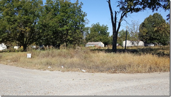
Looking northwest across the property from the corner of Goose Lane and Duck Circle

20161024_100602
Looking north across the front yard and Duck Circle.

20161024_100705
Looking north across the backyard.

20161024_101114
The liqour store (center) and the homestead (right) from across the highway.

1955 East Prairie Reunion
Jesse and Viola on the south side of the house. 1955
J~L- (8)At Grandpa's


J~L-1980 (4)

above-left
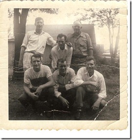
the brothers: Red, Noble, Jesse, Les, OJ & JD.                                   about 1949

above-right
Kizzie and some grandkids: Sheila Littrell, Jerry Davis, Mary Catherine Littrell & Billy Davis.                                  1955

above
Bobby Jimerson, Red & Rubin.    1980

Same garage in the background

JDL-1955 (9)
The front yard 1955 Reunion.
Remember the tree with the noted roots that we used to sit and play on?

J~L-1980 (14)
The front of the house in the 80s
J~L-1980 (22)
The shed in the back. 1980s

20161024_100537
All the structures are gone now and the property grown over with tall grass and weeds. As of 10-22-2016 the property is for sale.


[Using the map below
or
the “Littrell Family Places” tab at the top of this page]

Gary,Courtesy of Amand06 Lres
During our conversation the other day I forgot to mention that I had the homestead location on the Littrell Family Places map (on the website) here is that info.

  • Go to the Family website ( www.littrellfamily.net  )
  • click on the tab at the top of the page titled "Littrell Family Places) that will take you to another of my websites (Glenn's World) and it will show a map (may take a few seconds to load.
  • In the center of that map is a icon (marker) of a white house with a red roof, near Sikeston.
  • click that icon and it will open up a dialogue box which you need to leave open for now.
  • Use your mouse to zoom in on the location of the house: do this by clicking on the ' +' sign on the top left of the map.
  • Do this until it won't zoom in anymore. This is as far as you can go in the terrain view of the map.
  • The house is setting just off of Highway 105 on the corner of Goose Lane.
  • Now click on the 'Hybrid' button at the top of the map and you will change to a satellite view with map features overlaid (you can eliminate the map overlay by clicking the 'Satellite' button.
  • If you want at anytime you can close the dialogue box by clicking the 'X' in the right hand corner of it, but be aware that with the box closed the map will no longer keep the icon perfectly centered on the map. You will have to manually do it.
  • Now that you are out of 'Terrain' view and in either 'Hybrid' or 'Satellite view notice that you can zoom in more.
  • Do so by once again using your mouse to zoom in on the location of the house: do this by clicking on the ' +' sign on the top left of the map.

JL Homestead


GlennDL

Thursday, July 14, 2016

Tenant Farming in the Missouri Bootheel: 1930s

Updated and reposted 7-14-16

Grandpa John and Uncle James brought their families to the Bootheel area of Southeast Missouri in the early 1930s. As tenant/sharecropper farmers they faced hard and unfair times trying to establish a foundation for rearing a family.

The depression hit most Americans in the 30s but farmers and farm workers had been facing economic depression since the 1920s and win the rest of the country was hit by the stock market crash the farmers had already been living the hard life.

Dawn to dusk farm hands were paid a measly $.75 a day for picking cotton. Tennant farmers and sharecroppers constantly faced mass evictions, company stores and landlord controlled price fixing.

Uncle Jim was a tenant farmer from 1930 to 1936 and grandpa John through most of the same decade. They both lost a son to farm accidents during that time.

gdl7-16
On Highway 62 from Charleston to Ft. Defiance.
gdl7-16b

We have no reason to believe that either John or Jim participated in the strike of 1939, but it would have been hard to not be aware of 1,000 tenant farmers and their families lined up along Highway 61 and 62 in the Bootheel.

Jim Donie Kizzie John

Aunt Donnie, Uncle Jim, Grandma Kizzie and Grandpa John Littrell.

20

Tuesday, April 5, 2016

The Tennessee to Missouri Migration:

Comer, James Littrell, John Littrell, Littrell, Belew, Thurman, Curtis, Shelton.

Migration from Lawrence County, TN to the bootheel of Missouri:

  • 1929                  James Carrol & Donie (Ezell) Littrell John’s brother (& Donie is Kizzie’s cousin)
  • 1929                  Edward J. Littrell a cousin of James and Grandpa John Littrell was also in the Bootheel, he and a son would die there and his wife, Laura E. Brown Littrell would return to Tennessee. UPDATE 1-10-2015: They moved in 1929,
  • 1930               UPDATE 1-10-2015:  The parents of Laura Littrell (above), Francis M. Brown & Martha Ezell (Kizzie’s Cousin), would join Laura and Edward Littrell would bring their family in 1930. Both parents, a brother and a sister would also die in Missouri, prompting Laura to return to Tennessee in December of 1941 after the death of her son.
  • 1932                 Grandpa John & Kizzie Littrell
  • 1925-1935        William Denise Belew(TN, 1886-1959) and Iva Shelton Belew (AL, 1894-1969), sharecroppers, with 3 of their children. Daughter Corene married John’s son Noble. Like Grandpa John they were in New Madrid County in 1935 Remember, Kizzie’s grandmother was a Belew also.
  • 1935-1940         Leslie Comer and Aunt Claude (Powell) Comer, Leslie was Kizzie (Comer) Littrell’s older brother.
  • 1945                   Jesse Littrell (John’s son) & Viola (Johns – Simbeck) Littrell would  move from TN in 1945 to East Prairie, then to La Forge in 47 where Jesse was a sharecropper,

1940 Census:

  • John Littrell HOH, age 52    Page 23A, Enumeration District 67-4  John is listed as living in rural Mississippi County, in an area that appears to be about a mile and a half east of Anniston.
    The 1940 census information indicates that this general area may have been where John & Kizzie were sharecropping this area in 1940. Children in the household are: Red, JF, Letha May, OJ, Lesley, and Rubon.  The census taker recorded Rubin as Rubon, but remember the census taker wrote it the way he heard it, or mis-heard it. On the other-hand the reviewer/transcribers of the census read JD's initials as JF. They too are reading it as they say it, and in the census takers handwriting it could be read JF, JP or JD. The only person besides John who has an occupation listed is Red, listed as a laborer. according to this census John & Kizzie were living in New Madrid County, Mo., in 1935. Our research indicates La Forge (sharecropping).
    1940CensusMap JohnDL
  • Listed in the same household census page as John is his son, Noble Littrell(24) and Corene (Belew) Littrell(20), also sharecroppers.  Page 23A, Enumeration District 67-4
  • Seven households down from Noble & Corene (on the other side of John) is Corene's parents William Denise Belew(TN, 1886-1959) and Iva Shelton Belew (AL, 1894-1969), sharecroppers, with 5 of their children. 1940 Census indicates that William's family lived in New Madrid County in 1935, same as John. Could they also been at La Forge then?
    Corene Belew's family also migrated from Lawrence County, Tennessee; living on Westpoint Road in 1920 with Iva's parents: W.E. & Mattie Shelton. Corene was a twin. Civil District 2, Page 7A, Enumeration District 84

    Noble and Corene were married in Charleston, Mo., 10-18-1939. Corene died in 3-8-1943 and was born on 10-19-1919. Burial: WOW (Memorial Park) Cemetery, East Prairie Mississippi County, Missouri, USA. Double headstone with twin sister Florine, who died 5 years earlier. 
  • Bertha Littrell Thurman is living in Anniston Village, St. James Township. with Bordie. Census indicates that Bordie lived in St. James since 1935. He actually was born there. He shows on the 1920 census with his parents in Anniston Village. StJames Twnship
  • Lesley Comer and Aunt Claude (Powell) Comer LA Comer 50 (10-31-1889) Farmer (Rented: does this indicated sharecropper?) St. James Township (St.James Township includes Anniston Village & East Prairie). Census Indicates that Leslie was farming in Rural Tennessee, Lawrence County in 1935. Present in Household: Claude (46), Virgle (19), Lucille(16), OC(14), Willard(11). 1940 Census  Page 810B, Enumeration District 67-10 
    Leslie signed his name Leslie on his 1917 Draft Registration Card, born in Loretto, TN.
  • Onene Littrell Curtis  Shows on Census as living in Marston, with Bert and daughter Martha Rae. Name was written as Anene.
  • Jess Littrell, 30 HOH Lawrence Tennessee Page 8A, Enumeration District 50-3  Jesse is living northwest of Loretto: Busby & Westpoint Rd. The census indicates that he is at the same residence as in 1935. He listed as a farmer, no indication that he is or isn't sharecropping. Children in the household: Beatrice, Dola (Should be Dolan), Willadean (should be Willa Dean), Christine, Geneva and James (Bud).

see also 1930 Census entry for John Littrell & R. Benjamin Smith: Lawrence County, TN.

Tuesday, September 15, 2015

Evergreen Cemetery: Missouri

John and James Littrell brought their families to the Bootheel area of Southeast Missouri in the early 1930s. As tenant/sharecropper farmers they faced hard and unfair times trying to establish a foundation for rearing a family.

The depression hit most Americans in the 30s, but farmers and farm workers had been facing economic depression since the 1920s and win the rest of the country was hit by the stock market crash the farmers had already been living the hard life. OLC-18 (1) wname

Dawn to dusk farm hands were paid a measly $.75 a day for picking cotton. Tenant farmers and sharecroppers constantly faced mass evictions, company stores with landlord controlled price fixing.

James was a tenant farmer from 1930 to 1936 and John through most of the same decade. They both lost a son to farm accidents during that time:

  • James's youngest son JC died in a tractor accident at age 8, he was riding on the tractor with his father when the tractor rolled over pinning JC under the wheel.

  • Earlier that year John's 21 year old son Troy Lee “Dick” Littrell died after being kicked by a mule.

Evergreen Cemetery is less than 5 miles from the LaForge Community.

Dick was the only child of John and Kizzie buried in Evergreen. He is buried in an unmarked grave at this time, 85 years after his death.

Most of James's family is buried in Evergreen Cemetery, including JC.

Capture

Sunday, May 17, 2015

Pearl Littrel Counts:

This is an inquiry from Donna Bryant (on Facebook) of Anniston, MO., concerning her grandmother. If you have any information that might help use the comment link for this post.  I don’t have an email address for her to post here, but any I will relay comments to her via FaceBook.

Hi my name is Donna I am trying to find some information on a lady named Pearl Littrel Counts she was. My mothers mom I know she my had lived in the STL area I just wanted to find a pic or information on her she would be deceased now

Wednesday, December 17, 2014

Our Ancestral Movements: From Virginia to Missouri

While we have been developing the story of the family’s Missouri migration from Lawrence County, Tennessee to the bootheel region of Missouri  we have seen more information falling in place on earlier migration stories:

  • We know our Littrell cousin’s we’re at the founding of Boonesborough and the blazing of the Wilderness Road with Daniel Boone. They came through the Cumberland Gap as some of the first settlers in Kentucky.
  • We know that our Littrell ancestor and his cousins migrated to Kentucky, and then to Tennessee, eventually settling in the same areas as other families that were their neighbors in Virginia.
  • We know that our Littrell ancestor and his neighbors and cousins also came through the Cumberland Gap and were among the first settlers to the area around the, then nonexistent, community of Dunnville, Kentucky.
  • We know that some of our Ezell Cousins, traveling with the Bumpass Party from Union County, South Carolina would be amongst the first settlers in the area of Giles County. An area that would eventually grow to be the town of Pulaski, the county seat of the newly expanded Giles County, Tennessee. Possibly also coming through the Cumberland Gap into Kentucky then Nashville, Tennessee.
  • We know that our Littrell ancestor from Dunnville, Kentucky and some of his cousins and neighbors would be amongst the first settlers in the newly formed county of Lawrence. Settling just miles from the Giles County, Tennessee settlers. Some of these settlers would be from the same families that migrated with our Littrell ancestor into Kentucky.
  • We know that our Ezell ancestor, along with our Belew and Comer ancestors and some of their other Union County, South Carolina neighbors would move into the same area as our Littrell ancestor in Lawrence County, Tennessee just miles from their Ezell cousins and uncles in Giles County, Tennessee.
  • We know that the same descendants of those Littrell, Comer, Belew, and Ezell families, and their neighbors would once again migrate into the same neighborhoods in another state. This time into the bootheel area of Missouri (see also) during the Great Depression leaving over a hundred years after their ancestors settled Tennessee. (see more)

These Virginia and South Carolina neighbors lived within miles of each other in their original neighborhoods and then in their new neighborhoods in Kentucky and Tennessee they once again were neighbors, and again in Missouri. In some cases they belonged to the same churches as each other in their state of origin and state of destination. They inter married with the same neighbors in both states and left families in their old neighborhoods with each migration. We can identify some moves as a group and some that were individual families moving over short periods of time.

Wednesday, December 3, 2014

The Family’s Migration Story: Tennessee To Missouri Ferry

The story told about Uncle Jim's journey references “...they landed in New Madrid on the ferry...”. The story told of Grandpa John's journey does not reference how they got across the Mississippi River. In trying to trace the journey and migration of John & Kizzie family from Tennessee to Missouri, I investigated several possible crossing points in Mississippi and New Madrid counties.

We know of four ferries in the New Madrid area: the Dorena-Hickman Ferry, the Belmont-Columbus Ferry, and the Tiptonville Ferry (Ferryland in Missouri) and the New Madrid Ferry.

  • The only one still operating is the Dorena (MO)-Hickman(KY) Riverboat Ferry crossing. Having ridden it several times during this research its history is sketchy and appears to have been an on again off again operation for sometime.

  • The Belmont(MO)-Columbus(KY) Ferry is probably the oldest of the four ferries, dating back to 1825. The community of Belmont was located north of Dorena and like Dorena no longer exist. The only reference to the Belmont-Columbus Ferry I have found is one that mentions it was established in 1825 and was re-opened in 2014. I will investigate this on my next trip.
    Belmont-Columbus Ferry

  • Tiptonville-Ferryland Ferry, I was checking out the Point Pleasant, Missouri area when I was directed to a place called 'Ferryland' to the south. It looked to be very promising, primarily because when I spoke to several people fishing on the bank they were familiar with the history of the area and the ferry landing. They pointed out the corresponding landing on the Tennessee side of the river and affirmed that it the Tiptonville Ferry was in operation in the 20 and 30s, that it also operated off and on maybe as late as the 70s. (Ferryland, State Highway 162 dead-ends at the rivers edge)
    On a subsequent trip I went to Tiptonville. I found the ferry location (Tiptonville Ferry Rd.) and once in town I was informed that one of the owners of the ferry in the past was still alive. I was directed to the local Ace hardware store owned and operated by the former ferry owner and his son. As it turned out he and his father owned the ferry and they, with his son had all worked on it. Unfortunately (see New Madrid Ferry below), he informed me that the ferry wasn't in Tiptonville until 1950.

  • New Madrid Ferry, with Uncle Jim's migration story “...they landed in New Madrid on the ferry...”, the first place I started this search was in New Madrid, but on several visits I was always told there had been no ferry in New Madrid. This was always a letdown because Troy and I had vague memories of a ferry ride in the area. It was because of the negative responses I got from the New Madrid search that I started looking for other possible crossing locations like Dorena, Belmont and Tiptonville.
    In the above paragraph on Tiptonville I finish with the unfortunate news that the ferry was not in Tiptonville until the 1950s, this news was unfortunate for only a few moments, for as the conversation continued he revealed that his father had moved the ferry to Tiptonville from New Madrid!
    He could not date how long the ferry had been in New Madrid but he said New Madrid was a logical location until a sandbar had developed that interfered with the ferry.

As is the case quite often in this type of research a little mis-information, or missed information, can send you on a maddening detour.

ferry map

There were several things I learned about ferries that would influence the movement of a ferry: sandbars, droughts (sometimes more so than floods), new roads, shrinking towns, river traffic, competition, and changes in ownership.

The case for the New Madrid Ferry

Ferry Crossings were more common than bridges in 1929 and 1932. The most logical route would have been due west to Memphis and a crossing there or somewhere north of there to Tiptonville, Tennessee which is directly across from New Madrid County, MO.
In 1929 there was only one bridge across the river between Memphis and St. Louis. So one has to assume they crossed by ferry somewhere from Memphis to Cairo. Even though there were bridges in Memphis and the newly opened (old) Cairo Bridge (at the current Ft. Defiance location), they might have still taken a ferry if the toll was cheaper. Back then most bridges were toll bridges. In addition we can rule out the use of the Cairo bridge since it was only connecting Missouri and Illinois, not Kentucky, the Cairo-Kentucky bridge over the Ohio River was not yet built.

In the case of Grandpa John’s migration the same scenario would apply. The fact that John's migration story makes no mention of a ferry doesn't mean they took a bridge. Bridges were infrequent, newer, expensive and probably had higher tolls. Ferries on the other hand were more numerous, older and less costly.

Let’s look at the most logical routes:

1926us enlarged

On this 1926 map Lawrence County was on the state line between Columbia, TN., and Florence, AL., and New Madrid was at the top of the bootheel on the Mississippi. Keep in mind this map shows only the main roads, by necessity back roads would be used, but for major portions of the trip the main roads shown would most likely be used.

There would be three choices in 1929 and 32:

  1. From Lawrence County go due west or south to Highway 72 which would take them to Memphis where they would then cross into Arkansas and then take Highway 61 north to New Madrid. Even today, using the newer interstates, this is a possible route.
  2. At Memphis take  Highway 51 north and then the backloads west to the river and a ferry (New Madrid)
  3. From Lawrence, go northwest to Highway 45, take it north to Highway 51. From there go west on back roads to the ferry(New Madrid) or go north on Highway 51 and then west on back roads to the ferry(New Madrid)

All three routes appear practical, we have no knowledge of conditions that would favor one rout over the other except for three things: the third route appears to be more direct as it angles northwest towards New Madrid, the third route also avoids Memphis (would Memphis be an enticement or a deterrent to these hill folk?), and last, but not least, the second and third routes literally require a ferry to New Madrid.

So, until we have evidence, or at least information, that contradicts taking the family’s migration story literally doesn’t the New Madrid crossing make since?   

GlennDL~~2014

note: There were two other possible ferries (one in Caruthersville and I think the other in Dyersburg? I will look into this in the future.

END OF PAGE

Remember, each page has a limit on how many articles can appear on that page. When you reach the bottom of a page use the “Older Post” link under the last article(ABOVE) to view/see if there are more articles.

You can use the “Newer Post” and “Older Post” links to navigate back and forth between pages.